THE NAVIGATION SOFTWARE SPECIALISTS
+44 (0)23 9298 8806
Home Products Price List Dealers Contact About Us Support Downloads Shop
Download Brochure
Download Brochure
"We chose seaPro.. an easy to use,fully featured package". Sir Robin Knox-Johnston, Times Clipper.
The standard other systems are measured against

The highly acclaimed seaPro standard is a unique electronic charting application designed to offer seamless selection of both vector (Livechart & S57) and raster formats such as BSB from various supliers.

Comprehensive navigation features including integrated tidal data, passage planning, weather overlays, data logging etc.,makes seaPro a truly powerful charting and navigation tool. 

With an abundance of practical and easy to use features designed to make navigation quicker and more precise.

Key Features  
Click image to enlarge
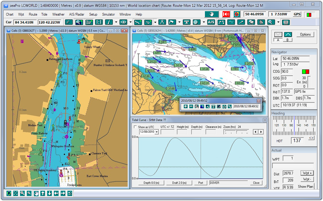
Multiple chart windows - Plan and monitor your passage in different windows at different levels of zoom. Alternatively monitor your position in one window while planning your passage in another
 
Built in support for multiple chart types both vector and raster BSB,Livechart and the new official S57 data (option). Seamless change between the different formats - allow seaPro to automatically choose the best scaled chart for you
 
Arrow Navionics chart option - with this 'add on' use your own Navionics charts (Gold and Platinum) - currently not available  
Flashing light sequences (on vector charts as available)
 
Chart zoom & panning tools - move around charts quickly and easily
 

Route planning and monitoring - Position waypoints easily by clicking the mouse button or edit them manually for precise positioning. 'On Route' information includes bearing and distance to next waypoint, ETA to waypoint. All routes can be saved and re-used as required . Routes and waypoints can be uploaded and downloaded to a GPS (with standard NMEA 183 upload/download capability)
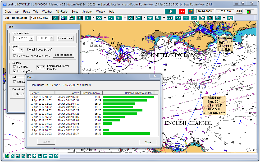
 
Tidal passage planning - Using tidal data from official sources, where available, seaPro will calculate passage time, expected ground track, course to steer and best departure time. You can also enter your own tidal diamonds
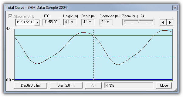
 
Tidal curves - The tidal curve function enables the display of tidal heights for ports where SHM data is available (including secondary ports). A world-wide tidal curve database is available as an option.
 
Tidal streams - Where available, visual tidal vectors can also be displayed on the chart or can be manually entered
 
PC Radar interface - display radar overlay images on the chart, plus full control of the radar from within seaPro - requires Koden Radar PC  
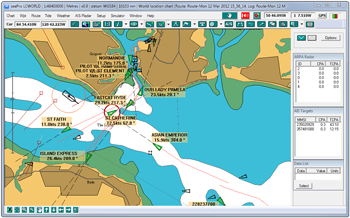
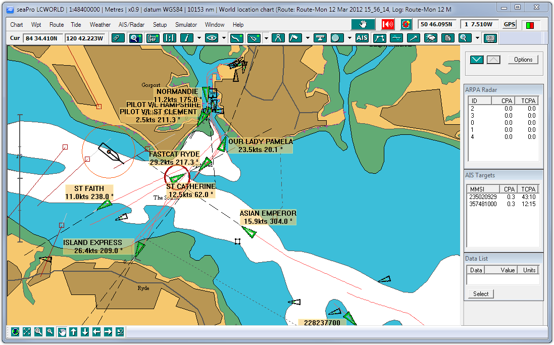
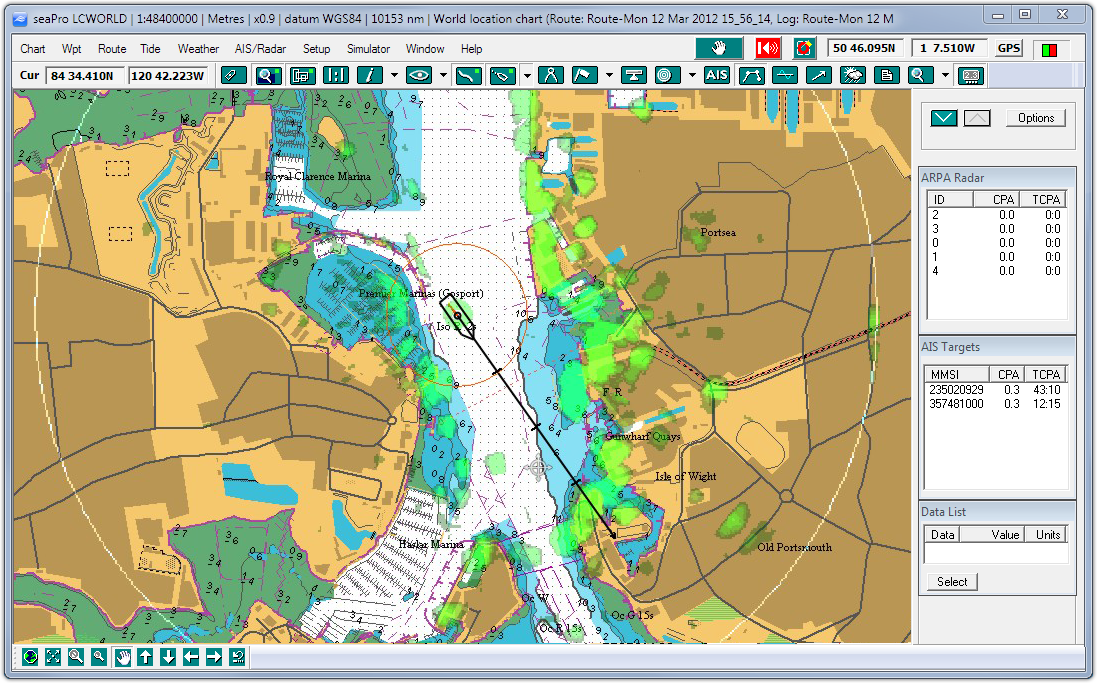
ARPA radar interface - display radar targets overlayed on the chart, with extended track line and information on Close Point of Approach (CPA/TCPA) etc. when interfaced to a suitable ATPA/MARPA radar with NMEA 183 output  
  AIS image  
AIS display - Display information from any AIS transponder or receiver to see information on other vessels equiped with AIS transponders (class A or B). Works with the Euronav low cost AI3000 Receiver  
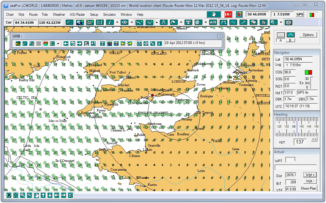
Weather information download GRIB weather files and display the weather patterns over your charts -wind, presure, wave height, temperature etc.
( depends on the source of your weather information).
Use the GRIB weather data when automaticaly calculating your passage plan (weather routing)
 
NAVTEX interface - supports the optional dual frequency NAVTEX engine  

Top 10 Frequently asked questions


PC requirements

Compare seaPro versions

Download a demo


Download a brochure


PC radar
more

Radar image

Radar overlay (green)

Tidal curve image
seaPro - designed for sail and power


Fuel calculations - For the powerboat and motor yacht owner, this feature gives estimated fuel consumption when planning a route.
Instrument Panel - Interfaced to your instruments via NMEA0183, seaPro will display this information in the repeater panel (position, log, wind speed & direction, depth, heading & temperature)
Position & Track Logging - GPS data is automatically written to the log at predetermined intervals and can be replayed or reviewed at a later date. Drop different 'marker flags' to indicate 'man overboard' or points of interest into the log with a single press of a button
Log Playback/animation of previous own vessel log
Autopilot control - seaPro will drive an autopilot that has NMEA0183 compatibility.
Chart overlays - Add your own marks, lines, areas and text to your charts with the overlay facility. Great for marking out your favorite fishing, anchoring or diving spots
Polar diagrams - The wind/speed performance characteristics of a sailing yacht can be entered and updated. This is then displayed graphically as a polar diagram and enables you to determine the maximum boat speed achievable for a given wind speed and wind angle
Weather routing - For sailing yachts, planning is made even easier. Using information on your yachts sailing performance (polar diagram), tidal data and predicted wind (from a GRIB weather file or manually entered) seaPro will calculate the best route either between two points or from your route, adding tacking points as required making best use of wind and tide. If you have more than one sail plan you even get suggestions when to change sails

Voice output - The voice output feature will keep you updated on your vessels speed, heading and progress along your route at either fixed time intervals or when the information changes (English version only)

 
Demontrating GRIB weather overlay - Click image to enlarge
Demontrating Route and Tidal calculations - Click image to enlarge

Options
Download the demo to fully appreciate how navigating with seaPro can make your time at sea easier and safer.
Navtex
A cheaper and more efficient way to display Navtex information. Simply purchase a low cost Navtex antenna, then weather and safety information can be directly received and displayed in seaPro.
 

Performance sailing
Maximise your yachts performance. Suitable for cruisers and racers alike..
World wide tidal heights database
Adds a world wide database for most of the worlds primary and secondary ports