THE NAVIGATION SOFTWARE SPECIALISTS
+44 (0)23 9298 8806
Home Products Price List Dealers Contact About Us Support Downloads Shop
Download Brochure
Download Brochure
"seaPro Performance Sailing enables us to get maximum boat speed without expensive instruments" Tom Somberg, Shalabais X442
The standard other systems are measured against

seaPro Performance Sailing has been designed for sailors who cruise or race and want to get more performance out of their yachts.

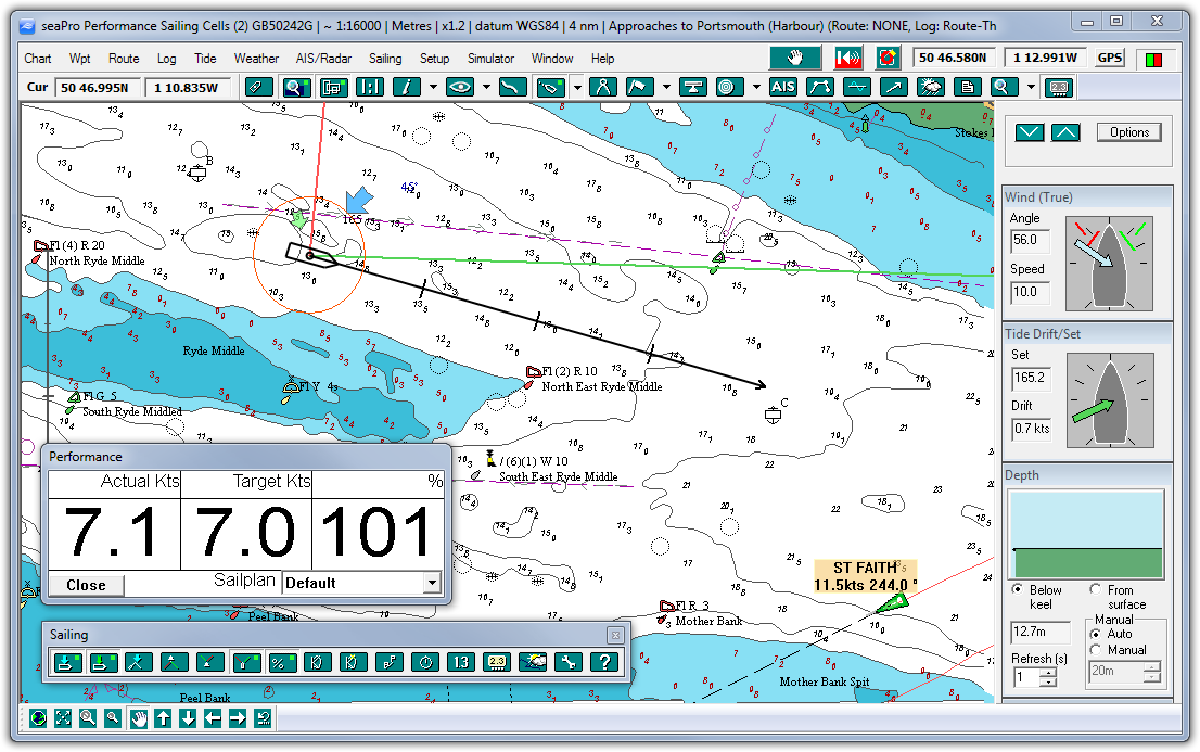
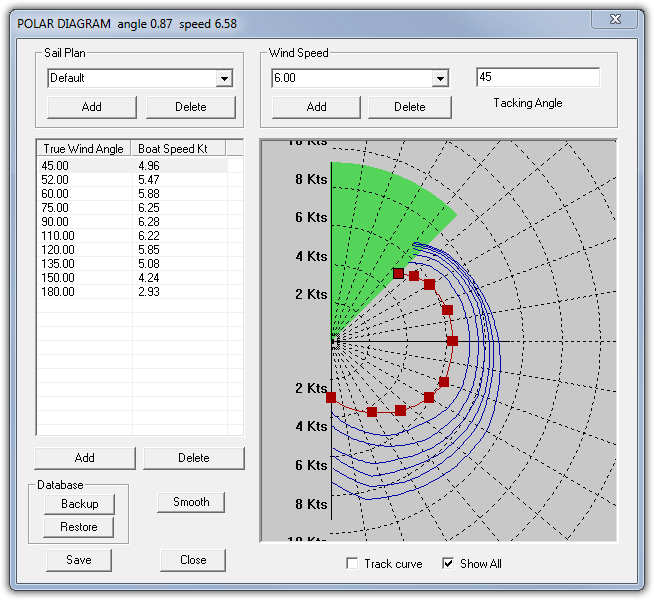
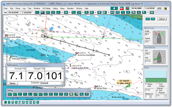
All the features of seaPro Standard and adding many features that enable you to sail faster, visual tools are provided including geographic wind direction, tacking angles and laylines, so you get the maximum information by simply looking at the screen.

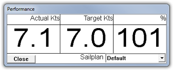
For yachts without expensive racing instrumentation, seaPro can provide information such as target boat speed, time to layline etc.

Output is provided to interface to dedicated mast displays such as B&G, Silva, NKE and the wireless Tacktick system.

seaPro Performance Sailing has been used on the Clipper Round The World yacht race and the choice system of Alex Bennett Racing, among many others worldwide

Key Features  
Click image to enlarge
Visual wind direction - The geographic wind direction is displayed as an icon relative to the vessel, with numeric wind speed and direction
Visual tacking angles - User configurable, these are displayed from the vessel
Visual laylines - These are displayed on the active waypoint and will continually update taking into account the wind and tide. The laylines can also be shown from the target marker flag, allowing quick changes of tactics
Wind on Next Leg - After entering your course this feature will display the wind direction on each leg. This will help with preparations for spinnaker pole setup and tactical planning 
Polar data auto-update - Aallows polar diagrams to be updated from live incoming instrument data (polar information can also be entered manually for various sail plans)
Performance meter - Sisplays your current boat speed, target speed and performance percentage
 
Enhanced weather routing - Tune for the best route taking into account weather and tidal conditions to give the best performance possible. Define no-go areas and the planned route will not cross these zones
Race planning - Start & finish line positions can be entered including race route with indicators for port and starboard marks. A start countdown timer can be displayed with audio start and warning signals
Instrument displays - Up to nineteen ‘virtual’ instrument (data repeaters) can be displayed on screen. Each instrument can be configured to give a voice output (English version only)


Top 10 Frequently asked questions


PC requirements

Compare seaPro versions


Download a demo

Download a brochure
download brochure


seaPro in use on Clipper Round The World yacht -
Gold Coast Australia

 
Mast Displays - from leading suppliers such as B&G, Silva and NKE are supported with special NMEA 183 outputs - provide vital performance information where you need it most - on deck
True Geographic Wind - Show the' wind direction, in a perfect world this would be the same as the weather forecast (but it probably won't be !) - great for visualizing future tactics and wind shifts.
Current Tide Stream - The current tidal stream is shown as an arrow close to the yacht indicating rate and direction. The shown stream can either be the predicted value, from the instruments (VDR) or calculated from GPS/Heading speed values
Tactical Race Panel - A simple window allows you to setup and modify a race route, complete with start and finish lines, port/starboard passing of markers - Great for round the cans racing where simple and quick race planning is required
Advanced Logging Features - High performance data logging of your instrument data, allowing monitoring and analysis of your sailing performance.
Start Timer - Multiple start countdown timers can be displayed with audio start and warning signals. Start line position can also be overlaid on the screen.
 
performance
Performance Sailing generates and modifies your polar diagram automatically. The up to date polar is used in the advanced weather routing to make best use of the predicted wind and tide.


Options    
Navtex
A low cost and more efficient way to display Navtex information. Simply purchase the dual frequency Navtex engine, then weather and safety information can be directly received and displayed in seaPro.  
  Worldwide tidal heights database
Adds a world wide database for most of the worlds primary and secondary ports  
    AIS receivers