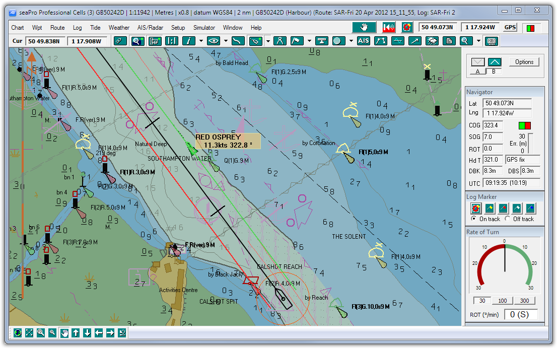
THE NAVIGATION SOFTWARE SPECIALISTS
+44 (0)23 9298 8806
Home Products Price List Dealers Contact About Us Support Downloads Shop
Download Brochure
Download Brochure
 
Total navigation for the professional mariner

seaPro Professional is a powerful electronic charting and navigation system designed for the modern Navigator (sub-ECDIS).

Available as software or fully integrated bridge system, seaPro provides practical real-time navigation that interfaces to GPS, ship board sensors and ARPA radar's. Used together with high quality digital charts such as S57, Livecharts or ARCS, seaPro provides the ideal central navigation station.

Note: The use of paper charts is still required, unless a fully compliant ECDIS system is used with ENC (S57) charts.

Key Features  
Click image to enlarge
Improved safety
Real-time navigation
At a glance’ situation awareness
 
Overlay of ARPA radar targets on charts
 
Automatic “look ahead’ view for maximum clarity
 
Weather overlays
 
Chart corrections on CD ROM to eliminate human error
 
Data recording of voyage for incident investigation
 
Supports S57 data and ARCS charts ( weekly update option) as well as Livechart and BSB
 
Option for AIS
 

Computer requirements


Download a demo (plus version)

Look Ahead
seaPro provides both Relative motion and True motion modes.

Relative or ‘Look ahead’ mode enables the vessel to remain at a fixed position giving the navigator a clear view ahead of the vessel. In this mode the chart is automatically scrolled in the background allowing true ‘hands-free’ operation.

In addition the chart orientation can be set to the following modes:

Route Up
North Up
Heading Up


Route Planning
seaPro Professional contains advanced route planning facilities that enable tidal and magnetic variation to be automatically calculated in passage plans.

Schedule information including ETA and time-to-go are provided in addition to a print formatted passage plan.

Route and waypoint information can also be sent to an Autopilot, GPS and ARPA radar.

Integrated Weather Information
Weather data from various official Meteorological Offices can be delivered via email and animated within seaPro to show up to 5 day weather forecasts. Information that can be displayed includes pressure, wind speed, wind direction and wave heights.

Special Applications
seaPro Professional can be customized by Euronav for special applications - please call for details.

Increased Operational Efficiency
Practical route planning tools enable passage plans to be quickly calculated or checked
Charts can be electronically updated
Additional charts can be ‘unlocked’ from an on-board CD
Routes and waypoints can be transferred to GPS or Radar to enable them to use the same data
Can communicate passage plans, logs, weather data and chart updates via email
Real Time Navigation
seaPro Professional automatically provides the navigator with real-time position of the vessel and other important information for situation awareness, including:
ARPA target position and vector information
Repeated data from other sensors including Log and Gyro
Projected position from Heading or Course Over Ground
Vessel Track
Scaled vessel outline
Look Ahead View

Chart Formats
seaPro is a ‘multi-fuel’ platform that supports both Raster and Vector chart formats to provide the best choice of charts world-wide.

Vector chart formats
S57 ENCs - Official Hydrographic Office charts. AVCS and Primar.

These represent the ultimate in digital charts coming directly from the official source of information. Available with weekly NTM update contracts.

Livecharts - Euronav’s vector charts
High quality vector charts.

Raster chart formats
ARCS - British Admiralty charts offering worldwide coverage. Weekly update service available.

Seafarer - Australian Hydrographic Office charts covering Australasian waters.

NZ Mariner - New Zealand Charting Authority charts covering New Zealand waters.

BSB - National Oceanographic & Aeronautical Administration charts covering US waters.

Chart corrections
Chart update services as frequently as once per week are available depending on chart format and type.


Options
Navtex
A cheaper and more efficient way to display Navtex information. Simply purchase a low cost Navtex antenna, then weather and safety information can be directly received and displayed in seaPro.


Network
seaPro can network to other computers for multiple navigation stations and can also be used as an information repeater for example in the masters or officers cabin or for the Euronav PI3000 Passenger Information System.
World wide tidal heights database
Adds a world wide database for most of the worlds primary and secondary ports
  AIS Automatic Identification System
Interface to an AIS transponder to allow the positions of other vesels to be plotted on the chart